
Last modified: 2025-01-04 by olivier touzeau
Keywords: soule | basque country |
Links: FOTW homepage |
search |
disclaimer and copyright |
write us |
mirrors
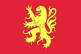
Flag of Soule - Image by Olivier Touzeau, 4 June 2022
See also:
Soule was first mentioned as a territory in a text from the 7th Century. In 636 (or 635) the Frankish army led by the Duke Arembert was ambushed and defeated by the Basques in a place named "vallis subola". This valley is then included in the territory of the "Wascones" (Duchy of Vasconia), which included intermittently lands to either side of the western and central Pyrenees. It was later referred to as Gascony. The region of Soule may have developed a first political structure before the 11th century with a strong influence of the Kingdom of Pamplona, established in the year 824. In 1023 Sancho VI Duke of Gascony named Guillaume Fort as first Viscount of Soule. His descendants would inherit the title for around two centuries. The Viscounts of Soule had their base in the fortress of Mauléon, created in the 11th century, when the Viscounty of Soule was formed: a castle motte erected on a hillock, simply composed of a wooden tower, flanked by a barnyard, the all protected by a palisade surrounded by a ditch. The viscounts of Soule took advantage of their territory. Despite being small in size, it held a strategic position between the Kingdom of Navarre to the south and the Duchy of Aquitaine to the north.
In the year 1152 Eleanor of Aquitaine married Henry II of England, thus the Duchy of Aquitaine joined the Crown of England. In 1261, after ten years of conflict, the last viscount of Soule, Auger III, surrendered the castle of Mauléon to Edward I of England, and as a result the territory of Soule was administered by the crown of England. At this time the network of roads between the villages of Soule was constructed. The English Soule was under direct authority of the Duke of Aquitaine, who was also the King of England. Control over the territory was delegated to a lord, who kept the castle of Mauléon and collected the taxes. The lord of Soule had fourteen captains, of whom only one was English, the rest being either locally-born or Gascons. Edward decided, to consolidate his power, to fortify Mauléon. The ex-viscount Auger III allied with the Kingdom of Navarre, and taking advantage of the war between Philip IV, king of Navarre, and Edward I of England, retook his fortress at Mauléon in 1295, but he was forced to hand it back after Aquitaine was formally declared English in 1303. The Hundred Years' War kept Soule isolated from the exterior for many years.
In 1449, an army of several thousand men commanded by Gaston IV of Foix-Béarn came to take possession of the castle of Mauléon in the name of the King of France. Soule was definitively united with the domain of the King of France in 1512. It is the smallest province of the kingdom and the furthest from the center of power. It is surrounded by the Kingdom of Navarre to the south and the Viscounty of Béarn to the east which were then independent.The Soule corresponds to the valley of the tributary Uhaitza (from "ur gaitza" meaning "wild water"), called Saison in French.
Just like the historical territories of the southern Basque Country in Spain (Alava, Biscay, Guipuzcoa and Navarre), the historical territories of the the northern Basque Country (Lower-Navarre, Labourd and Soule) had “regional forums" which represented the autonomy of these territories. These forums were abolished on the night of August 4, 1789, in the midst of the French revolutionary ferment. These regional assemblies, made up of delegates from each commune, excluded or limited the power of the privileged people of the time, namely the nobility, the nascent bourgeoisie and the clergy. During the division of France into departments, in 1789, proposals to create a Basque department, in particular by Dominique Garat, were not followed up and on March 4, 1790, the three provinces were grouped together with Béarn and with the Gascon lands of Bayonne and of Bidache and Soubestre to form the department of Basses-Pyrénées, now Pyrénées-Atlantiques.
Olivier Touzeau, 4 June 2022
The flag of Soule is a Banner of arms, red with yellow lion.
It has been observed in the capital of Soule, Mauléon-Licharre: photo (2008), photo (2010), photo (probably ~2011), photo (2011), photo (2016), photo (undated)
Olivier Touzeau, 4 June 2022


